
Picterra
A geospatial image analysis platform used for training and deploying machine learning models.
Introduction
Platform for training and deploying machine learning models for geospatial imagery analysis.
What is Picterra?
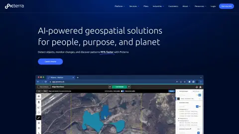
Picterra is a software platform designed to train, deploy, and manage machine learning models for the analysis of geospatial imagery. It enables users to detect objects, monitor changes, and identify patterns in satellite, drone, and aerial images at a speed of 95%. Picterra offers geospatial artificial intelligence solutions for various industries, helping companies optimize their workflows, rapidly identify objects, and promote sustainable development efforts.
How to use Picterra?
Users can upload satellite images, aerial photos, or drone footage to the Picterra platform to create custom AI models that are capable of detecting objects, changes, or patterns. They can then share their analysis results through interactive dashboards and reports. This platform is also integrated with Esri ArcGIS Pro and Safe FME.
The core functions of Picterra
Construction of custom AI models for geospatial imagery analysis
Object detection, change monitoring, and pattern recognition
Integration with Esri ArcGIS Pro and Safe FME
Interactive web reports and dashboards
Object detection, change monitoring, and pattern recognition
Integration with Esri ArcGIS Pro and Safe FME
Interactive web reports and dashboards
Visits:13
Updated:2026-11-07
Related






1
 2
 3
 4
 5
 6
 7
 8
 9
 10

Zlibrary
Zlibrary is known as the world's largest digital library, containing 9,826,996 e-books and 84,837,646 journal articles. From various well-known literary works, science and engineering, humanities and arts, to academic papers, etc.! Support PDF, epu
Sweezy Cursors
Sweezy Cursors is a website that offers a wide range of personalized mouse cursor resources. It features thousands of cursors and pointers with various styles and dynamic effects, covering categories such as anime characters, game weapons, emojis, cartoon animals, technological themes, vector graphics, and popular film and television characters – all designed to suit your needs.
New Orylia AI
AI picture and video generator that remembers your aesthetics
Jina AI
Search for AI providers that offer features such as embedding, reordering, and advanced search capabilities.
HeyGen
AI-generated digital human videos
Manifold MCP
An MCP for connecting AI agents to real-time marketing data
The Legacy App
A platform that uses artificial intelligence to capture and preserve family memories and stories.
Conju – Build AI Powered Apps
Through LLM-driven follow-up and integration with CRM systems, Conju converts unanswered calls into sales opportunities.
LinkFox AI
AI tools designed for cross-border e-commerce
Nexusbots AI
Nexusbots AI offers unlimited business automation services for a fixed monthly fee.
1
2
3
4
 5
 6
 7
 8
 9
 10

Zlibrary
Zlibrary is known as the world's largest digital library, containing 9,826,996 e-books and 84,837,646 journal articles. From various well-known literary works, science and engineering, humanities and arts, to academic papers, etc.! Support PDF, epu
LinkFox AI
AI tools designed for cross-border e-commerce
HeyGen
AI-generated digital human videos
DuiYou AI
Duiyou is a service platform developed by Alibaba Design to support designers throughout their entire career journey. It builds its capabilities around five key user values—quality, efficiency, skills, achievements, and income—to fully serve designers, with the goal of becoming their trusted partner.
Refined through multiple rounds of development by design teams from leading tech companies, Duiyou combines a vast collection of high-quality 3D assets, real-time online rendering, diverse scenario-based applications, a lightweight, easy-to-learn, and user-friendly interface. It also comes with free, commercially usable features, providing professional designers, marketing specialists, students, beginners, and social media influencers with a zero-cost online design platform and resource library.
PixPix
Generation of AI-based e-commerce templates and videos
Riffusion
Generative AI musical instruments enable the creation, remixing, and sharing of high-quality songs based on textual prompts.
OptimizerAI
The AI sound effect generator is capable of generating an unlimited number of high-quality sounds based on text or audio input.
StockTune
StockTune provides AI-generated royalty-free music for content creators to use without attribution.
PDF Converter
Free online tool for converting and editing PDF files.
A Cost-Effective Guide to Living a Better Life: HowToLiveBetter
Which membership services on my phone are automatically deducting fees from my account? Is the password for my main email address the same as that used on other websites? In the rental contract, when exactly will the deposit be refunded? Each of these issues, taken separately, is not particularly complicated. However, without anyone reminding you, it’s very easy to make mistakes. Today, I’d like to share a GitHub repository with 60.5k stars…
1
2
3
4
5
6
7
8
9
10
Zlibrary
Zlibrary is known as the world's largest digital library, containing 9,826,996 e-books and 84,837,646 journal articles. From various well-known literary works, science and engineering, humanities and arts, to academic papers, etc.! Support PDF, epu
LinkFox AI
AI tools designed for cross-border e-commerce
HeyGen
AI-generated digital human videos
DuiYou AI
Duiyou is a service platform developed by Alibaba Design to support designers throughout their entire career journey. It builds its capabilities around five key user values—quality, efficiency, skills, achievements, and income—to fully serve designers, with the goal of becoming their trusted partner.
Refined through multiple rounds of development by design teams from leading tech companies, Duiyou combines a vast collection of high-quality 3D assets, real-time online rendering, diverse scenario-based applications, a lightweight, easy-to-learn, and user-friendly interface. It also comes with free, commercially usable features, providing professional designers, marketing specialists, students, beginners, and social media influencers with a zero-cost online design platform and resource library.
PixPix
Generation of AI-based e-commerce templates and videos
Riffusion
Generative AI musical instruments enable the creation, remixing, and sharing of high-quality songs based on textual prompts.
OptimizerAI
The AI sound effect generator is capable of generating an unlimited number of high-quality sounds based on text or audio input.
StockTune
StockTune provides AI-generated royalty-free music for content creators to use without attribution.
PDF Converter
Free online tool for converting and editing PDF files.
A Cost-Effective Guide to Living a Better Life: HowToLiveBetter
Which membership services on my phone are automatically deducting fees from my account? Is the password for my main email address the same as that used on other websites? In the rental contract, when exactly will the deposit be refunded? Each of these issues, taken separately, is not particularly complicated. However, without anyone reminding you, it’s very easy to make mistakes. Today, I’d like to share a GitHub repository with 60.5k stars…